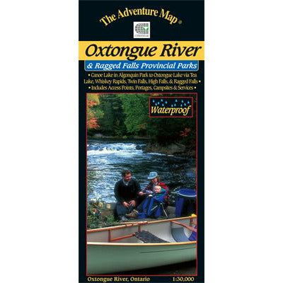
Oxtongue River Provincial Park
Oxtongue River Provincial Park
SHIPPING CALCULATED AT CHECKOUT
Couldn't load pickup availability
This 1:30,000 scale map of the Oxtongue River area covers the river itself from Oxtongue Lake in the west to Canoe and Smoke Lakes in Algonquin Park to the east.
There are several access points and routes to choose from including the Oxtongue River itself (either downstream or upstream), Oxtongue Lake, or the Park Lake to Bluebell Lake section of Algonquin. Highlights along the routes include thundering Ragged Falls, Whiskey Rapids, Twin Falls, and High Falls.
With campsites, portages, access points, rapids, falls, historic features, hiking trails, facilities and lots of other helpful information this map makes an excellent resource for daytrippers and those seeking a short two to three day adventure.
This map overlaps with our Frost Centre map to the south, our Algonquin 1-Corridor North and Algonquin 3-Corridor South maps, and our Algonquin Canoe Lake map to the east. Also consider our other larger scale Algonquin Daytripper Maps of smaller popular areas (Bonnechere River, Opeongo Lake, Canoe Lake and Barron-Achray) suitable for short trips of a week or less.
Waterproof, as usual.

Our Promise
Quality Gear
All the products we sell are carefully curated from years of testing in the field. If we haven't used it, and don't trust it, we won't sell it.

Easy Shipping
Not only are all orders over $50 shipped for free across Canada, but we also offset the carbon emissions associated with every shipment.

Satisfaction Guarantee
We guarantee all the products we sell. Same goes for any advice we give you. Got an issue with your gear? Contact us and we'll get it sorted.